Posts

Showing posts from January, 2019

Lab 3 [GIS5050L]: GIS & Cartography
Image
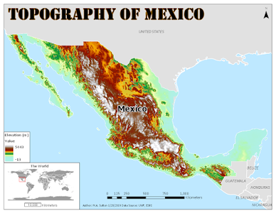
Built using ArcGIS Pro 2.0 This map shows the topology of Mexico (measured in meters) with an inset map demonstrating the placement of this country in the world setting. The color ramp selected for the elevation data was based on one of the standard ramps used for elevation inside ArcGIS. The map can be improved by selecting a lighter color blue for the background ocean information so the elevation information near the coastline is more prominent.

Lab 2 [GIS5050L]: Own Your Map - Essential Map Elements and Presentation Skills Lab Assignment

Image
Created with ArcGIS Pro 2.2.0 This map was created to highlight the location of the main campus of the University of West Florida (UWF), while also noting the major interstates, rivers, and cities within its home county of Escambia County, within the State of Florida.  The inset map in the top right corner is used to highlight how this county (noted in red) is located in the western Florida Panhandle area.  The larger map is used to mark the relevance of the notable features (interstates, rivers, and cities) to the location of the main campus of UWF, which has been highlighted with a red school-shaped building symbol.  The color choice on the larger map (pale yellow) is used to enhance the river color (blue) along the borders of the county.

Lab 1 [GIS5050L]: ArcGIS Pro Overview Lab Assignment

Image
Created with ArcGIS Pro 2.2.0 The map above was generated during the first week of GIS5050L to emphasize various features available in ArcGIS Pro 2.2.0 for customizing the layout, title, legend, scale bar, north arrow, and text characteristics on an exported map.