Lab 4 [GIS5935]: Surfaces - TINs and DEMs
Raster-based digital elevation models
(DEMs) and vector-based triangulated irregular networks (TINs) are two
alternative methods to represent digital topography. A DEM is sampled at a particular
resolution and can only be made more accurate if the raster is resampled to a
higher resolution. Alternatively, to make a TIN more accurate, additional points
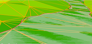
and breaklines can be added. For example, in the image below, to make the sharp
boundaries around a lake more accurate, the TIN has been forced to use the exact
boundaries and elevation of the lake polygon (shown in red):
In
the enhanced TIN above, notice how the TIN grid aligns perfectly along the shoreline
with the addition of many more triangular cells in this area. Additionally, more
triangles appear near the bends in the shoreline to more accurately capture
these details.
In this lab, we also learned how contour
lines differ when derived from DEMs versus TINs. We observed that contour lines
generated from a DEM are much smoother in appearance than the ones generated
from a TIN. Because DEMs are a raster providing a regular grid of spot heights,
by default they will produce more uniform calculations of terrain variables
like slope and aspect (Boldstad, 2016, pp. 485). For example, notice in the
image below how analysis based on a TIN (contours in pink) doesn’t do well on the
sharp boundaries of water bodies (darker green area), compared to analysis
based on a DEM (contours in bright green):


Comments
Post a Comment