Lab 2 [GIS5027L]: Land Use / Land Cover Classification and Accuracy Assessment

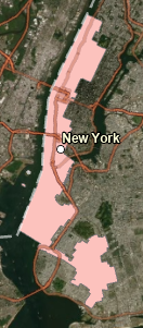
This map demonstrates practice creating polygons representative of land use / land cover by examining the underlying features in the aerial photograph for details relevant to classify at Level II of the USGS Standard Land Use / Land Cover Classification System.
This lab further demonstrated ways to utilize Google maps as part of ground truthing a random set of 30 points drawn throughout the image to measure overall accuracy (shown in the map above at 70%).
This lab further demonstrated ways to utilize Google maps as part of ground truthing a random set of 30 points drawn throughout the image to measure overall accuracy (shown in the map above at 70%).


Comments
Post a Comment