Lab 5 [GIS5027L]: Unsupervised and Supervised Classification
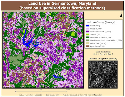
This week's lab focused on using the tools within ERDAS Imagine to perform unsupervised and supervised classification of pixels representing various features in an image. In the map above, supervised (maximum likelihood) classification was used to classify pixels based on eight different classes of land use.
The results above demonstrate many urban/residential areas were misclassified within the roads class. The results can be improved by selecting more signature samples for these two classes and then also evaluating these signatures to determine the optimal 3 bands that help with differentiation prior to running the classification algorithm. Two helpful tools in ERDAS Imagine for signature evaluation include examining histogram plots and mean plots of the image bands of the features you are seeking to differentiate.


Comments
Post a Comment