Lab 12 [GIS5050L]: Georeferencing, Editing, & 3D
Created using ArcGIS Pro 2.2.0
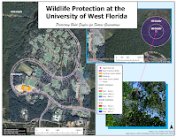
First, we learned the process to select control points for image registration, referred to as georeferencing. For the map shown on the left, this involved selecting points in the raster image and linking them to their corresponding point in a loaded vector feature class (e.g., corner of a building). Several transformations were possible based on the number of control points selected, target root mean square error (RMSE) values, and the desired appearance of the final registration (e.g., choosing a 1st or 2nd order polynomial transformation based on which one minimized RMSE or distortion).
This week's lab also emphasized editing of feature classes in the form of adding polygons and lines to existing building and road feature classes, respectively. The process of digitizing these features was based on using the outline of the item in an underlying raster image. We also learned how to use the Multiple Ring Buffer tool, as shown in the image on the left, for highlighting conservation easement areas to protect a bald eagle nest on the UWF main campus.
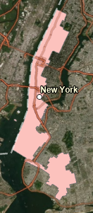
Finally, this week's lab emphasized best practices when using the LAS Dataset To Raster tool to render LIDAR data into a DEM layer that could be used to augment the visualization of features with 3D characteristics. For the map you see on the right above, buildings appear with 3D-like features based on draping them over the DEM layer while making adjustments for their known height (stored in the attribute table).


Comments
Post a Comment